
Bangalore to Munnar via Salem
Bangalore to Munnar via Salem and Avinashi is one of the popular driving choice to Munnar
T
ake this route if your need is to get to Munnar, through the fastest road route.Munnar from Bangalore via Salem: Distance 478km
Bangalore → 40km → Hosur → 50km → Krishnagiri → 110km → Salem → 60km → Bhavani → 20km → Perundurai → 42km → Avinashi → 22km → Palladam → 56km → Udumalaipettai → 88km → Munnar
You will be driving on the NH-44 and NH-544 during most of the journey and then cross Indira Gandhi National Park to enter Kerala at the Chinnar Wildlife Sanctuary. Of course the route mentioned above have many alternate roads and bypasses to skip many towns.
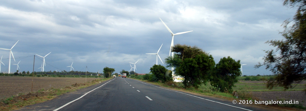
Exit Bangalore City & hit the highway
So let’s look at the first stretch of this route, that is from Bangalore to Salem. The first task from Bangalore is to get is to get to NH44. Basically you've to head towards the southeast of Bangalore city ( towards Koramangala, Electronics City ) to join NH-44. You can even take the NICE road to join NH-44. Now head towards Hosur on NH44. From Hosur you have two options, the first is to continue on the ‘swanky’ NH-44 itself towards Salem or take a less busy road ( SH-17 ) via Rayakottai and Palakodu to join the HN-7 again after Dharmapuri.
Though fast moving with 4 lane, the traffic on NH-44 ( Hosur > Krishnagiri > Dharmapuri stretch ) is a bit busy with racing buses and too many trucks.
If you are looking for a relaxed driving take the Rayakottai – Palacode route. The route is more scenic and rural. It’s a bit shorter too than the other route, but doesn't make it faster.
So whichever option you've taken, from Dharmapuri onwards you are on NH-44 all the way up to Salem. You would have crossed Thoppur and Omalur on the way before Salem. The Bangalore to Salem stretch is about 200km. It could take anything from 3 to 4 hours of driving for this stretch.
Change the Highway at Salem
At Salem you’ll leave the NH-44 and take the NH-544. In fact you will not be entering the Salem city as the bypass around the city connects you to the NH-544. It is a very busy bypass road ( 6-lane) around the periphery of Salem city. Ask for the Kandhampatty bypass junction where you can see the flyover where NH-544 starts. Keep left as you approach, never miss the entry point. Once on the flyover, you'll be getting into NH-544 ( starting point of this highway) at the clover.
Leave NH544 Highway at Avinashi
Your next diversion point on NH-544 is after a town called Avinashi. This is at about 120 km from the Salem bypass. You will cross the Bhavani , Chithode and Perundurai towns (bypass) before reaching Avinashi town. At Avinashi ask for the Udumalpet (Udumalaipettai) road (SH-166). That is you'll leave NH-544 by taking a left turn ( into SH-166) after Avinashi town towards Udumalpet.
Another 75 km straight south from Avinashi, you will reach the Udumalpet town, after crossing Mangalam and Palladam. Alternatively, while on NH 47 , a shortcut to reach Palladam ( you will skip Avinashi) is to take the left deviation at Perumanallur. This road goes via Tiruppur and joins the Udumalpet road at Palladam. You’ll save some 10km in this shortcut.But this is quite a busy route till Tiruppur.
Another alternative route between Perundurai and Udumalpet is via Dharapuram. At Perundurai leave NH 47 for Udumalpet via Kangayam and Dharapuram (bypass). You'll skip most of the traffic. The route is scenic, 2 lane.
The Ghat & National Park stretch
Udumalpet to Munnar, the final lap, is about 90km long. From Udumalpet town ask for the Munnar road. A few minutes later the chain of mountains appears in the horizon. You are shortly in for a long drive through the forests of Western Ghats. After Udumalpet town The road is typically narrower with umpteen curves, turnings and steep climbs till you reach Munnar.
About 30km from Udumalpet on the fringes of Indira Gandhi National Park (Tamil Nadu) is the Chinnar Wildlife Sanctuary (Kerala) , the entrance to it marks the Tamilnadu Kerala border. You needs to complete some formalities at the check post ( checking the vehicle/baggage, entering details in the register etc ) before entering the wildlife sanctuary. Munnar is some 60km from Chinnar Wildlife Sanctuary. Its a 10-12 kilometers drive through the sanctuary and then the road pass through a thick canopy of bamboo forest. As you exit the sanctuary, you’ll reach a small town called Marayoor. Beyond the tea plantations starts. Now those classic images of rolling hills with tea gardens keep appearing till you reach Munnar town. Marayoor to Munnar is about 40 km. Somewhere midway between Marayoor and Munnar is Anamudi in the Eravikulam National Park. This is the highest peak (2695 meters / 8842 ft ) in South India and of Western Ghats.
Well, you've just crossed the home to the largest surviving population of Asian Elephants, and the Nilgiri Tahr, which not found elsewhere in India. That is in addition to a host of other wildlife including Bisons, Tigers and antelopes.
In short you will pass the Anamalai Wildlife Sanctuary ( Indira Gandhi National Park), Chinnar Wildlife Sanctuary and Eravikulam National Park before reaching Munnar Town. Udumalpet to Munnar is about 60 km.
So that’s about the Bangalore to Munnar road route via Salem and Udumalaipettai. Have a safe drive!
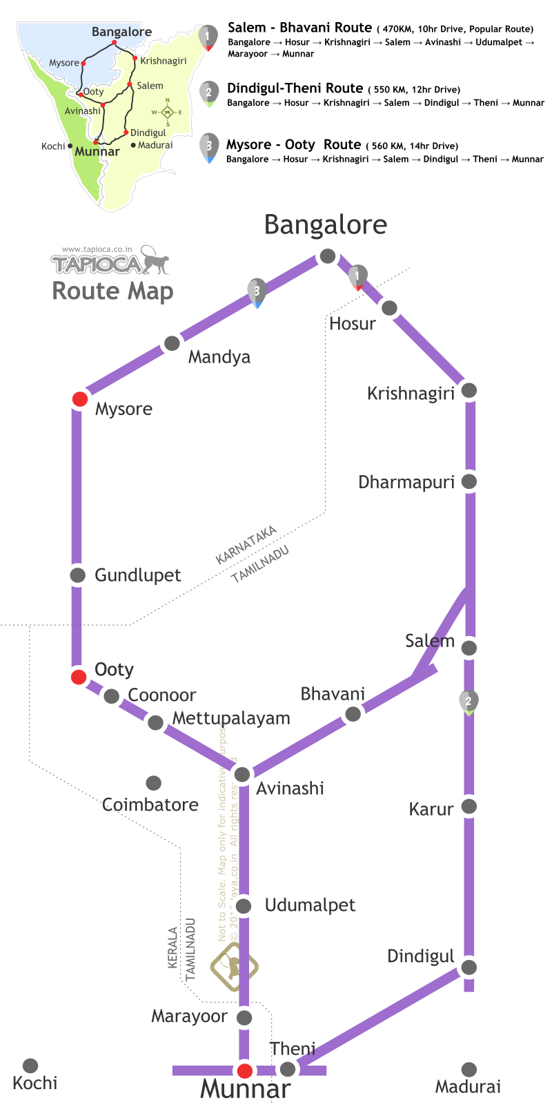
Bangalore to Munnar Road Route Map
Bangalore to Munnar Road Route Map