
Bangalore to Mananthavady via HD Kote
Bangalore to Mananthavady : Well, have a few route options to travel from Bangalore to Wayanad by road. Check the map below.
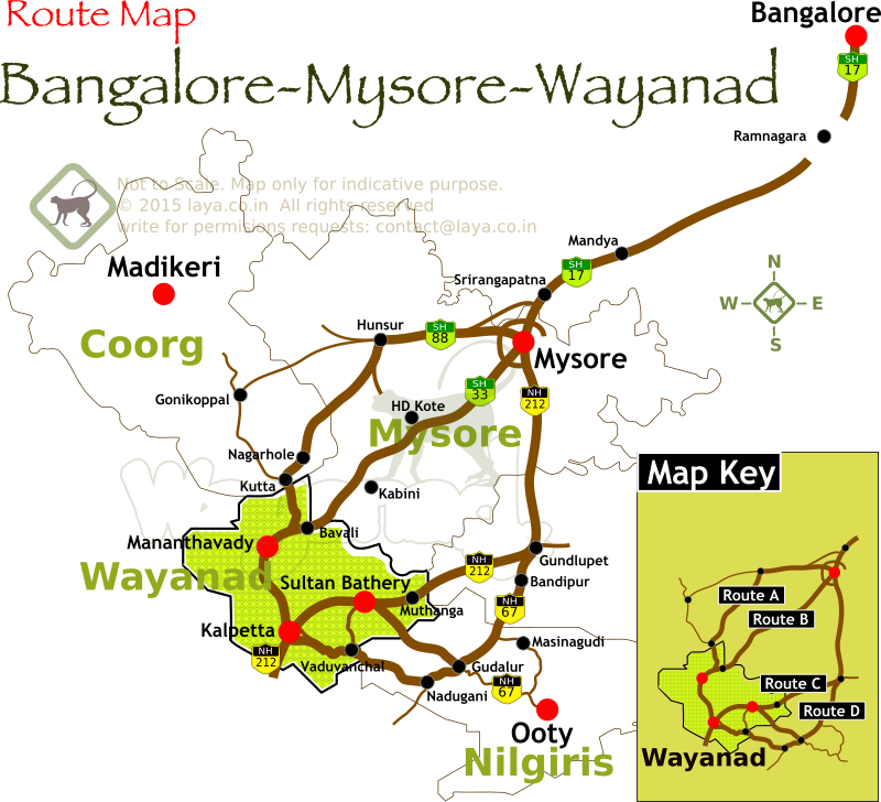
B
angalore --> 150km --> Mysore -- 50km --> HD Kote (Handpost) -- 24km --> Udbur (forest entry gate) -- 22km --> Bavali (forest exit gate) -- 7km --> Kattikulam -- 10 km --> MananthavadyThe Route B is very identical to Route A, to reach Mananthavady from Bangalore. At Mysore, drive right though the city and get to the SH 33 (popularly called the HD Kote road or Mananthavady) . You can easily reach to the highway (SH 33) from Mysore city center.
In about 1½ hours (about 60km) time you can reach Handpost Junction near HD Kote from Mysore. The highway (SH33) is in great shape all the way. 15 km after Handpost Junction (HD Kote diversion) you'll reach the entrance of Rajiv Gandhi National park. The traffic through the forest is blocked. You’ll see a closed gate across the highway.
Take the left diversion at the gate. The 12km or so of the bad stretch of the route starts from here. This bypass road goes around the fringes of the forest and many villages like Karapura fringing the forest.
Somewhere on your left you can see the Kabini backwaters at a distance. Your road is also the route for the famous Jungle Lodges in Kabini
The road re enters the forest at Udbur check post. You need to give details and sign a register before entering the forest. There is no fee to be paid. A few more kilometers later the so called bad stretch of the road ends and re joins the SH33 inside the forest. Take the left at the junction. It would easily taken an hour to cover this 12km stretch, that’s the condition of the road!
This is one of the dense forests in the region, with highest probability of wildlife spotting. It's not uncommon to spot even tiger on this route, especially during the mornings and evenings. While in the forest follow the cautions and etiquettes mentioned in the Route A details.
Unlike many roads through forests of this region, this road is pretty straight throughout the national park area. Before you exit the national park you would pass a few check posts and many tribal settlements.
At Bavali, you'll exit the national park and enter Wayanad district. That bridge marks the Kerala-Karnataka border. The forest continues for many kilometers before you reach the Kattikulam town. Kattikulam is the only place you can find a hotel or a fuel station after you've left the Handpost junction at HD Kote.
Baring the 12km stretch that is getting damaged progressively over the years, you'll find this route from Bangalore to Mananthavady a pleasure. The drive through the national park is of course a highlight. Very similar to the other routes through the forest, traffic is not allowed in the night (between 6pm and 6am).
Bangalore Mysore Wayanad Route
Bangalore Mysore Wayanad Route